सुगम्यता नियंत्रण
सुगम्यता नियंत्रण
पाठ का आकार बढ़ाएँ
पाठ का आकार घटाएँ
अंधेरा/प्रकाश विषमता
उलट देना
मुख्य लिंक
छवियों को छुपाएं
पूर्वनिर्धारित कर्सर
परिपूर्णता
थीम का रंग बदलें
सुगम्यता नियंत्रण
पाठ का आकार बढ़ाएँ
पाठ का आकार घटाएँ
अंधेरा/प्रकाश विषमता
उलट देना
मुख्य लिंक
छवियों को छुपाएं
पूर्वनिर्धारित कर्सर
परिपूर्णता
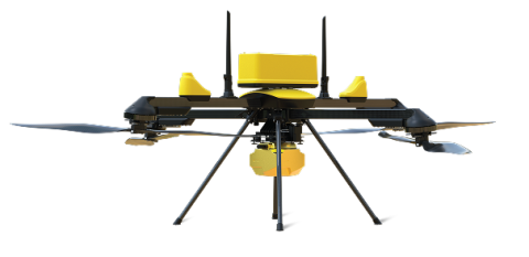
Introducing the Q6V2 GEO — the geospatial powerhouse in our Q6 Series UAV, now spotlighting military mapping excellence. With over 50 minutes of flight time even under LiDAR payload (under 7 kg MTOW), it conquers extreme terrains like Himalayan glaciers or dense forests for precise defense-grade surveys. Swappable payloads with RTK-enabled LiDAR, PPK geotagging, and custom DEM uploads make it unstoppable for mission-critical military mapping in any environment. This advanced quadcopter dominates ISR, border surveillance, tactical terrain modeling, and rapid battlefield cartography!